Asiulvesacam
When the Rasvrisuam returned to the Llof after the Sunfall, they arrived on two large, arid islands with little vegetation except in the shadier areas and along the rivers. The dusty, grey deserts were separated by steep, black mountains, the only colors being specks of red and ochre sand in some areas. When the Asiuluiam drove the Dakiuzuiam away, they probably weren’t too sad to escape the hot place, and found the cool, humid Cloud Palace to be a much more livable home. To this day, these lands are called Asiulvesacam “ash islands”.
One has to tell this story to explain the name, because nowadays, many parts of the country are covered with lush forests and colorful meadows. There are many Dakiuzuiam who envy the Asiuluiam their rich, beautiful nature. The reason for this transformation is not an accident of nature or a fortunate change of climate, but a thousand year long effort of terraforming and revegetation by the Asiuluiam, or “gardening”, as they humbly call it. They have bred and imported hundreds of plants and animals to create the unique landscapes you can visit today on the Asiulvesacam.
The Asiuluiam are not only masters of ecological engineering, but also very serious about their urban design. Traditionally, Asiuluiam lived among their extended family in small settlements of a few subterranean houses or caves to find shelter from the hot sun. You can still find these tiny “family villages” throughout the Asiulvesacam, but they have long been subject to very strict regulations regarding their size and distance to other settlements. This is to prevent the formation of densely populated areas and preserve the beauty of the surrounding nature. Many areas also have restrictions on the appearance of houses within their bounds, i.e. the architectural style and materials used for building, to generate a consistent look. The few larger cities are planned and designed by the Ministry of Gardening and each have a unique style or theme that usually also affects the regulations for the settlements in the city’s surroundings.
The Asiulen population is generally very supportive of this policy and there is a lot of national pride surrounding the “gardens”.
Overview over the Zanaam and cities
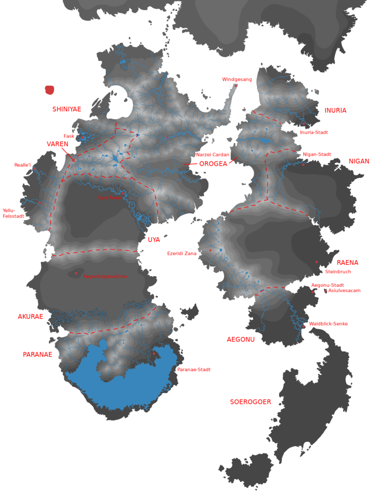
The Asiulvesacam consist of three large islands plus a few smaller ones. The land is further divided into 12 Zanaam “gardens” (similar to federal states). They used to have more autonomy in the past, but are now all governed by the four Masiuluiam. Five Zanaam cover the Black Island: Asiulvesacam (Capital), Aegonu, Raena, Nigan, and Inuria. Another six Zanaam are on the White Island (named after occasional areas with white cloud stone): Orogea (which also covers some land on the Black Island, but is counted towards the White Island), Varen, Uya, Shiniyae, Akurae, and Paranae. Finally, the third and smallest island is its own Zana, the Soerogoer.
Black Island Zanaam
The capital city of the Asiulvesacam, where the government resides, is also officially called Asiulvesacam, but usually only referred to as the Capital (Isles). It also constitutes its own Zana by law, but due its small size, there is no real gardening going on there. The Capital is built inside and on top the ruins of an old Rasvrisu city that float a few kilometers sunwards of the coast of Aegonu. The ruins consist of four large pyramids and a few smaller (but still big) rectangular buildings of black stone from the mainland. Most of the Capital’s population lives and works inside the four pyramids (the Main Isles), while the other ruins host the government complex, the airport, the hospital, the Ministry of Gardening’s breeding facilities, several parks, and the villas of the high society.
The closest Zana to the Capital is Aegonu, a hilly area mostly covered in high grasses and small groves. At the coast closest to the Capital lies Aegonu City, which is often regarded as the Capital’s outskirts, because many people who work in the Capital but cannot afford the housing there live in Aegonu City. Being one of the oldest large settlements on the Asiulvesacam, Aegonu City has a less unified look than other cities because it was not originally designed by the Gardeners. The modern policy is to mimic the Rasvrisu ruin look of the Capital.
Aegonu’s second city is Forestview Hollow (ger. Waldblick-Senke), named after its proximity to the Soerogoer (see below). Located in the delta of Aegonu’s main river, it tries to sport a cozy, forest-y look by incorporating wooden elements into its architecture, e.g. via timber framing. Forestview Hollow is a popular holiday home among the Capital’s high society, and also inhabited by many former Soerogoer residents.
Aegonu borders on Raena, a relatively untouched Zana, as the huge flat sunwards plains were especially hard to revegetate. Thus, most of Raena’s surface is still a desert, with a comparably high proportion of red sand. Along the sunwards coastline of Raena, there is plenty of easily accessible black stone exported to the whole country for building houses. One of the country’s largest cities is located inside an old quarry and is called… Quarry. Quarry has a rusty scrapyard aesthetic, the houses being stacked on top of each other along the old quarry’s steep walls, connected by metal bridges. The shabby look is misleading though, as Quarry has become very rich through its stone exports. It also has a big university and is extremely popular among academics, also due to its relative proximity to the Capital.
The non-sunwards side of Raena is dominated by a huge mountain range. The back side of these mountains is forested and hosts the Water Temple, one of the most intriguing Rasvrisu ruins of the Vesacam, on top of the range’s highest mountain, near Ezeridi Zana “Ezerid’s garden” (which is a city, not a garden, despite the name). We will learn more about the Water Temple in the next section about natural phenomena.
Similar to Raena, Nigan was also never reforested. At the mouth of its river lies Nigan City. I have yet to come up with a proper design for Nigan City.
The final Zana on the Black Island is Inuria, a hilly land divided by a mountain range, covered by a thick paper bark tree forest. Its main city, Inuria City, lies at the edge of the forest, and is a picturesque town of cute hobbit homes dug into the hills. It also has the headquarters of the Institute for New Worlds and Cultures, which is dedicated to creating and exploring new dimensions.
White Island Zanaam
Orogea, actually spanning both islands, is the largest Zana in terms of area, but also one of the most sparsely populated ones. It is covered by several large, hardly accessible mountain ranges with steep cliffs and thick, often jungle-like forests. The fauna is very diverse in Orogea, some harpy species can only be found in some isolated Orogean valleys. However, it is also the home of large, dangerous harpies that have been hunted down elsewhere. This is why most of Orogea is a wilderness that the Asiuluiam usually don’t travel through.
There are two large cities though: One, Narzei Cardan “fiery forest”, is located in the large valley with the same name, and is named after the red and yellow leafed trees growing alongside the river there. The houses in Narzei Cardan are made of wood and painted in many different bright colors. The other one, Windsong (ger. Windgesang), sits on top of the enormous stone pillars on the headland pointing towards the nearby Forest Dimension.
Varen is the only Zana without any settlements, being something like a national park. It is also the only one without a coastline and the smallest one, covering a system of deep canyons at the edge of the Orogean mountains, again home to many unique harpy species like the Verena, a harpy with limited shapeshifting abilities.
The mountains of Varen and Orogea feed a large river, the Uya Border River, which, as its name suggests, separates them from another Zana, Uya. The Uya Border River is not a natural river, but was formed by the Orogean gardeners to protect their Zana’s forests from the hot Uyan desert. The Border River has also brought some vegetation to Uya in the form of dry grasses and thorny bushes. However, they are frequently burned down by bush fires. A smaller city with the ironic name Uya Wetlands (ger. Uya-Auen) has sprung up along the riverbed of the Border River, consisting of small clay huts and the traditional subterranean housing.
A tall mountain range protects the nearby Zana Shiniyae from the fiery Uyan desert, endowing it with a temperate climate. The back side of the mountains, never seeing the light of the sun, is usually covered in ice and snow, bringing cool winds to the flowery meadows at the foot of the mountains. The natural beauty of the land and the pleasant temperatures make this Zana the most densely populated one (after the Capital) despite its smaller size. Shiniyae also has a long history of quarrel with the Masiulen government, having attempted to become an independent country several times in the past. It was also the only region that continued to be predominantly Ryka-speaking after the language was officially replaced by Asiul. However, when Ryka was put into use again, the Masiuluiam decided against adopting the White Ryka dialect spoken in Shiniyae, but instead revived Old Ryka as the official language. This has not helped to ease the conflict between Shiniyae and the Capital.
The Shiniyae’s largest city, and the second largest on all of the Asiulvesacam (after the Capital), is Realle’i (a portmanteau of “reality” and as. soele’i “dream, future”, supposed to mean “a dream come true”). Realle’i has two separate themes: In the Old Town, the buildings are designed after the style of the human architect Hundertwasser (and the river running through the city is named after him). The whole layout of this part of the city is very organic and asymmetrical, with narrow, curvy streets winding like rivers small streams between the colorful houses. Then there’s the New Town (also called Sidanlau “glass (tree) tops”), which presents itself in a futuristic eco architecture style, with tall glass buildings growing trees and other greens on walls and roofs. Realle’i is often regarded as a perfect representation of the Asiuluiam’s desire to live in harmony with nature.
Located at the foot of the Shiniyae mountain range is the Rock Town, often referred to as the Yellu Rock Town (ger. (Yellu-)Felsstadt). As the name suggests, the city has a large Yelluen population, and it is often considered the Yelluam’s capital on the Asiulvesacam. The city is seated on a huge white rock, and the houses are built and carved out of rock of the same color.
The third large city in Shiniyae is Fask, located on the Fask Lake. Most of the lake is covered in a maze of wooden bridges and platforms on which the houses are built.
South of Uya, separated by a small mountain range, lies another desert Zana, Akurae. The Akurae desert is famous for its colorful sands, giving its only city the name Rainbow Desert (ger. Regenbogenwüste). Rainbow Desert has a huge glasswork industry which produces beautifully colored glass wares from the surrounding desert’s sand. The city’s houses are made of colorful clay and present intricate stained glass windows.
The southern part of Akurae has a fascinating system of ravines coated in a species of fungus unique to this area. This fast growing fungus covers the walls of the ravines with its large spongy mass that has a similar texture to rock, creating the impression of the ravines being alive and closing up over time. This has given both the fungus and the whole area the name Filonken Ronkal “living rock”.
The final Zana on the White Island is Paranae, and it has the largest body of water on the whole Llof cloud plain, the Paranua “large water”. Most of the Paranua is only enclosed by a thin hill range which directly borders the cloud plain. Where the hills are low, evaporating water from the Paranua streams over the hills onto the plain as “mist falls” or “cloud falls”. At the coast of Paranae lies Paranae City with its majestic white houses.
The Soerogoer
Finally, there is the Soerogoer, located on its own island. From the outside, the Soerogoer looks like one huge forest, with the whole island being covered in large, lush trees. But the Soerogoer is actually the entrance to all forests: There are dimensional stairs and crossings that connect forests from all possible worlds that exist. Travel long enough through the Soerogoer and you can end up in the most fantastic forests imaginable. In its center, wherever that might be, there is said to be a gigantic tree that reaches into the infinite.
While the Soerogoer is officially a Zana of the Asiulvesacam, it is not really governed by the Masiuluiam, or by anyone else. It is inhabited by tribes of Nunulm-speaking Asiuluiam, Dakiuzuiam, and Yelluam, all Soerogoeruiam, as they refer to themselves. Even though their lifestyle is similar to the Free Tribes, they are usually not regarded as one of them. This is not only because they live on the Llof, rather than in another dimension, but also because all races actually live peacefully together in the Soerogoer. The Nunulm dialect in the Soerogoer is also very different from the dialects of the Free Tribes.
The Soerogoeruiam have a troubled past with the Civilized Asiuluiam, who attempted to colonize the Soerogoer after driving the Dakiuzuiam from the Islands and claiming the land. The Soerogoeruiam, or Vanaam “Savages”, as the Asiuluiam used to call them, were captured and imprisoned in concentration camps on the Islands, where they were forced to work for the Asiuluiam, for example helping them build some of their planned cities. Under a later Masiului, the concentration camps were disbanded, and the Asiulen government officially apologized for the cruelties against the Soerogoer’s original inhabitants. The Soerogoeruiam were then granted self-rule of the Soerogoer, while all Asiulen and Yelluen Soerogoeruiam also being recognized as citizens of the Asiulvesacam.
Notable natural phenomena
Cloud Wells
Since the land masses on the cloud plain of the Llof are not part of a planetary crust, elevations like hills and mountains are not formed by seismic activity. Instead, cloudy winds streaming under the islands have created “wind canals” under the surface, bulging up the land above. Cloud Fungus spores carried by the wind get caught inside the wind canals, start growing and eventually petrify, adding to the mass that gets pressed upwards. Large bubbles of petrified Cloud Fungus eventually decay in the center, becoming hollow, and condensed water accumulates within. Almost all mountains on the surface contain these Cloud-coated water bubbles.
When the bubbles eventually cannot carry the weight of the overlying rock anymore, they collapse, and the opened bubble forms a crater lake on top of the mountain. As humidity is still entering the crater from the wind canals below, these lakes are usually not emptied and will sometimes spill over to form streams and rivers. Also, evaporating water from the lake will cover the mountain top in a constant mist. Thus, these lakes are called Cloud Wells.
The Long Night and the Desert Bloom
For the Rasvrisuam, the beginning of a new year is marked by the Long Night, a solar eclipse that lasts for about three days when the planet Kabuki in the Star Dimension moves between the Llof and the sun on its regular orbit.
The nearing of Kabuki also has another effect: The planet’s magnetic field causes tidal movement of the Island’s bodies of water towards the sun (or rather, Kabuki). To be more precise, the Paranua is emptied shortly before the Long Night, and the water from many Cloud Wells spills over their sunward edge, causing temporary streams and rivers from several large mountains. The Raena mountain range floods the Raena desert, and the Uya Border River also usually causes large floods.
As a consequence of this, in the time after the Long Night, greens and flowers shoot up in the Paranua basin, the Raena desert, and parts of the Uya desert. The Paranua quickly fills up with water again after Kabuki has passed, but the Desert Bloom in Raena and Uya lasts for several weeks before the ground has dried up again.
The Water Temple
The largest mountain the the Raena range hosts a unique Ravrisuen ruin in its crater: The Water Temple. This structure is usually submerged in the crater lake and only surfaces in the two weeks surrounding the Long Night when Kabuki’s pull has decreased the water level. The Temple is a spherical building, its “walls” consisting of hundreds delicate black stone arches shaped like vines. Four staircases are spiraling down from the crater edges to the Temple, meeting a white stone floor placed inside the sphere at about one third height. The staircase also serve to anchor the sphere inside the crater, in addition to four stone beams securing it from the bottom towards the lower crater walls. In the middle of the white floor is an elevated stage or alter, also made of white stone. Even though the ruin has been submerged in water most of the time for hundreds, maybe thousands of years, the stone it is made of shows only little signs of wear.
It suggests itself that the Water Temple was used by the Rasvrisuam for rituals and celebrations surrounding the Long Night. But the details remain unknown. The miraculous resilient stone from which it was build, the fact that the sphere seems to be made of a single piece of rock (at least there are no detectable seams), how they managed to secure the building inside the mountain crater, are all mysteries yet unsolved. The Water Temple itself is inaccessible to the public, but many tourists visit the crater edge to catch a glimpse of the mysterious Temple year round. In order to access the crater edge during the “dry period” of the Water Temple, one has to book tickets at least a year in advance. Only scientists are allowed to actually enter the structure, and the Masiuluiam perform the traditional New Year celebrations inside the Temple, which is broadcast all over the country. The nearby settlement Ezeridi Zana only revolves around the Water Temple tourists.